“It was the best of times, it was…” – no let’s just leave it at that. This was a wonderful adventure. Other than some strong wind on one day, we had perfect weather. We enjoyed fun trails, incredible autumn foliage, and amazing views of the Grand Canyon.
I created two videos from this trip. Since I was in the lead most of the time, the video is mostly of pretty autumn leaves. Dave moved around within the group and created two videos that include riders much of the time. I hope you enjoy them.
The plan was to explore the Kaibab Plateau in a clockwise direction, camping on the rim of the Grand Canyon each night. We had to alter our route due to the Ike’s Fire, which closed much of the western rim. Dave was lucky enough to snag a permit for five to camp at Point Sublime inside the National Park boundary. We camped outside of the park the other two nights.
We staged near Jacob’s Lake at the fire lookout tower. This seemed like a reasonable place to start. There is enough parking for a few rigs, an outhouse, and it is just off Hwy 67 about one mile south of Jacob Lake Inn.
Staging area
We mostly rode on the smaller dirt roads inside the Kaibab National Forest. We rode on Hwy 67 when necessary, and a few times on the major dirt road #22 – but we didn’t enjoy that road – it was loose gravel and had a lot of washboard. In general, the smaller the road, the more fun it was on a dirt bike.
We met at around noon, ate a quick lunch and got ready to ride. We rode south, parallel to Hwy 67 until near the De Motte campground. Most of the roads were fun and fast, except for one section that had recently been graded. That one was loose and had hidden rocks in the dirt. We passed through a mixture of lodgepole pine and lots of colorful aspen trees. The aspen trees in old burn areas were particularly striking.
Colorful leaves in an old burn area
Riding through miles of colorful aspen trees
We eventually crossed over the highway and rode out to the eastern rim, camping near the Saddle Mountain trailhead. The best campsites were already taken, so we ended up on a fairly slanted camp with lots of thorn bushes. I worried that my air mattress would get punctured, but luckily, I avoided that problem.
It got pretty cold at night since we were at about 8800’ elevation. I expected the sunset and sunrise to be spectacular on the rim of the canyon, but the canyon goes into shadow and it was difficult to see and to take decent pictures. If I do this trip again, I would likely camp off the rim somewhere with a better primitive campsite.
Cooking dinner and watching the sun set
After watching the sunrise and eating breakfast, we packed up and headed into the National Park. We rode the paved road out to Cape Royal and Point Imperial. Some say this is the best twisty pavement in the state of Arizona. I don’t know about that, but it was a fun ride – even on a small dirt bike.
Ross and Danny at Cape Royal
We spent more time at the overlooks than expected, and ended up having to postpone our visit to the North Rim Lodge and Bright Angel Point. We bought gas near the campground, and headed out to Point Sublime.
Point Sublime is perhaps the best viewpoint in the park, but it is about 20 miles out on a rugged Jeep road. A few years ago, I got a flat tire in my Jeep and remember it being pretty rough. I worried that this would be a tough ride with our luggage, but it turned out to be pretty fast and super fun. There are a few challenging sections with steep climbs and descents and quite a few rocks, but for the most part, it was a fun ride. The last few miles reminded me of an Ewok forest from Star Wars. What’s not to like about that!
A scenic overlook on the way to Point Sublime
The campground at Point Sublime is a few hundred yards from the viewpoint, but it does have two picnic tables and an outhouse. The elevation is lower, so it was a warmer night as well.
We enjoyed watching the sunset and sunrise, then packed up for more fun riding. I think the ride out was even more fun than the ride in.
Ross taking a sunset photo
Sunrise panorama from Point Sublime
Our original plan was to ride north on road W4 and explore the points near the Rainbow Rim mountain bike trail. Unfortunately, that entire section was closed. We had to go all the way back to the highway, so we decided to visit the lodge and Bright Angel Point since we were so close. This put us behind schedule, but it was worth the stop.
Ross and Dave enjoying the ride back from Point Sublime
We then exited the park via Hwy 67. The ride through the park isn’t bad on a dirt bike since the speed limit is only 45 mph. But once you exit the park, the speed limit steps up to 65 mph. The terrain opens up and we had a strong side wind, so this part wasn’t much fun on my small bike. We gassed up at the North Rim Country Store (no water and no garbage cans) then headed back onto the trails.
We rode through Dry Park and ate lunch at the Dry Park fire lookout tower. The ranger shack offered good shelter from the wind.
After lunch we found a really fun and twisty road that headed west towards Crazy Jug Point. The view of the Grand Canyon from Crazy Jug is quite different from the other viewpoints we had visited. From here you can see the canyon head in a fairly straight line to the west for miles and miles.
We then road out to Sowats Point. This road was a little disappointing. There were a lot of ruts in the road, and lot of hunters looking for turkey. Plus, the view wasn’t all that great. The elevation dropped as we approached the point, but we wanted to camp up in the pines so we headed back.
Our original plan was to camp at Jumpup Point, but it was getting late and we decided to find a decent camp as soon as possible.
On our final day, we rode out to Jumpup Divide, but didn’t have time to visit the point. We then worked our way east, back toward Jacob Lake. We missed a turn and ended up riding south parallel to the highway rather than east. This added a dozen or so miles to our trip, but gave us one more look at some beautiful autumn leaves.
More autumn grandeur
During our four days, we rode about 375 miles through some really fun and scenic areas of the Kaibab Plateau. Everyone agreed this was one of the best adventure rides we have enjoyed. I hope to return again someday. It was amazing how much more spectacular the autumn leaves were if you get off the main paved highway and venture out into the wild.
Ross planned a dual-sport ride from Mtn Green, Utah to Alpine, Wyoming and back. Their plan was to leave Thursday evening after work and return late Saturday, for a total of almost 500 miles. I was planning on tagging along, but decided it was too long of a ride since I haven’t fully recovered from my torn rotator cuff. So, I decided to join them for one day of riding on Friday.
Years ago, I drove along Grey’s River Road from Alpine, Wyoming, to the south end of Star Valley. It was a long and dusty drive, but very beautiful. I have been wanting to go back ever since.
Ross’s route included Grey’s River Road, so I stayed at our family cabin near Afton, Wyoming and met them at the junction of the Cokeville Road and Smith Fork Road.
I put in 140 miles that day, with about 80 miles of dirt road. Other than the few sections of Hwy 89, it was a very pleasant ride for me. On don’t like high-speed highways on my small dirt bike. Luckily the traffic was very light.
Grey’s River Road has been greatly improved since I drove it in the 1970s. It is a nice road and makes an easy dual-sport ride – assuming the road is dry. As you move north towards Alpine, the road gets wider and has a lot more traffic.
The road follows Grey’s River from near the headwaters to the confluence with the Snake River near Alpine. The road grows in size as the river grows.
Here are a few photos from my ride:
Danny, Ross, and Scott finishing the Cokeville Road
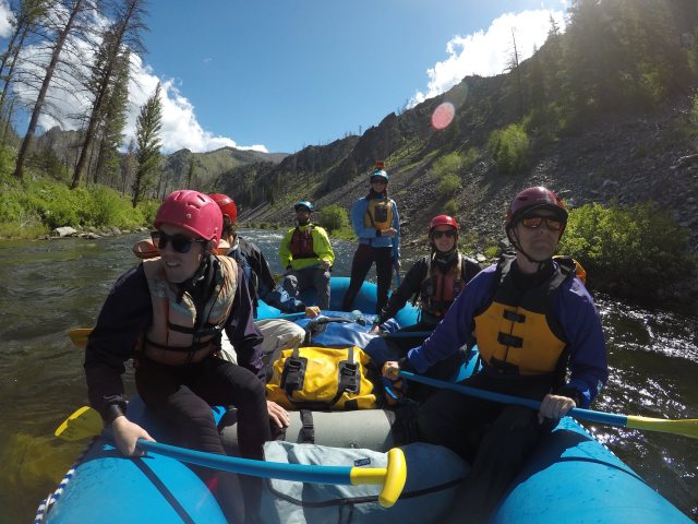
Gabe exercised “beginners’ luck” and drew a permit for the coveted Middle Fork of the Salmon River.
We had five rafts; Jamie captaining a 14’ paddle boat, with Dee, Layne, Barry, and Rob each managing a 16’ oar rig.
Captain Jamie and her crew
Dee’s boat
Layne’s maiden voyage on his new Sotar
Gabe giving Barry one of his few breaks from rowing
The Sorensen / Redd crew
Utah had an above average snowpack this year, but Idaho was pretty close to normal. The flow was 3.1’ when we launched on June 27, dropping to about 2.85’ on day 5.
The water was dropping about 1/2′ per day
For the most part, we had great weather. Day 2 was a little chilly, but day 3 was absolutely perfect with clear sunny skies and ideal temperatures. We had a few light rain sprinkles during the night at the Boundary Creek put-in camp and our final camp at Elk Bar, but otherwise avoided any rain storms.
Elk Bar was a fair campsite. This year the beach was fairly steep, making it challenging to find good tent sites. All of our other camps (Joe Bump, Lower Grouse, and State Land Left) were great.
State Land Left campsite
The Upper Canyon
Last year we launched with a flow of about 3.75’ – just over ½’ higher than this year. That small difference made a huge difference in the character of the river. The upper 1.5 days of the river is pretty swift and shallow, and difficult to pull over to stop.
The water was so shallow at the launch site, it was difficult to get in any solid oar strokes, so Rob and I both got snagged up on rocks right within site of the put-in. Things improved as we moved down river with numerous side streams adding water to the flow, but there were numerous places to get hung up or even wrap on rocks.
Jamie also had challenges because half of her six-man crew were newbies. They had no time to practice the basic raft maneuvering strokes, as is evident in the video. They did much, much better on subsequent days.
We got a fairly late start due to the crowd at the put-in (with one huge commercial outfitter), but luckily, we only had to go about 10 miles the first day. We stopped at Sulphur Slide for lunch, where Lee told of his brief swim in the shallow water. He reminded us to keep our feet downstream to protect ourselves from oncoming rocks.
After lunch I turned the oars over to Kevin. Sulphur Slide is long and rocky, and Kevin had no chance to warm up. We spun off a large boulder on the side of the river, dumping me into the river. The water is swift and shallow, making it almost impossible to keep my feet downstream to push off rocks. I had to lay fairly flat in the water, so I really couldn’t even see what was coming due to the waves. I bounced and slid off several large boulders and took on some huge bruises in spite of wearing a wetsuit. I was glad I finally invested in a good helmet. According to my helmet camera, I was in the water for almost two minutes before Kevin could get close enough for Isaac to pull me back into the boat. My advice is to “stay in the boat”.
Jason getting launched in Sulphur Slide
Sulphur Slide
Jamie and I each had clean runs through Velvet Falls. Last year I was unable to catch the Eddy and hit the deepest part of the hole. This year we ran it just as I planned. Rob was right behind me, and he hit the hole dead on. Luckily the flow was such that it didn’t cause him to stall and surf the hole for several minutes, as can happen at times.
The first portion of Powerhouse was shallow and wide. Lee (rowing Rob’s boat) went left and got stuck, so we went right. Isaac was able to successfully dodge all of the rocks and avoid getting stuck ourselves.
And in the final part of Powerhouse, Lee managed to pin on the same rock Jason pinned on last year. Rob climbed out on the rock to help push off the boat, only to be left stranded in the middle of the river. Jamie was able to pick him up down stream a bit so he didn’t have to walk all the way to camp.
Pistol Creek was pretty easy at these flows, but it could be dangerous if you got too far right and hit the large boulders. Jamie was a little too far right and went over one of the submerged rocks, but it didn’t cause any serious threat.
Jamie sliding over the rock in Pistol Creek
The Middle Section
The middle portion of the trip is mostly pretty tame in terms of rapids, but there are several nice hot springs through this section. We stopped briefly at Sunflower Hot Springs, and then took the one-mile hike up to the Loon Creek Hot Spring. The weather was so good, that the hot water wasn’t too appealing, but it was still worth the stop.
Sunflower Hot Spring
Loon Creek Hot Spring
We also stopped at the Flying B Ranch for an ice cream bar.
Steve and Jamie enjoying their ice cream
Tappan Falls and Marble Creek are pretty fun rapids in this middle section. Kathy and Kristen took a short swim in Marble Creek when their boat stalled briefly in the hole, catching them off guard. Kristen was startled when she came up underneath the boat, but quickly moved out from underneath.
Marble Creek
Tappan Falls is usually a fun ride down the tongue on river right. It has a nice drop and one big wave. This makes a good photo spot from either side of the river. You do want to avoid the holes in the middle, or you could be stuck for quite a long time.
Barry in Tappan Falls
The Lower Canyon
After the first 1.5-days, the river becomes a more traditional western “pool-and-drop” style river. The rapids get much larger as you move down stream and enter Impassable Canyon.
At some water levels Redside could be the most dangerous rapid on the river. At these flows, it was a pretty easy run, but you do have to decide whether to pull left or right of the ‘wrap rock’ waiting for you at the bottom of the slot.
Weber and Rubber were not as big as last year, but still offered good fun and decent waves. The other short, rocky rapids in the lower section were pretty easy to read-and-run, but you do need to pay attention or you could get stuck on a rock or in a hole.
We stopped to see Mist Falls and a waterfall behind the Parrot Cabin.
The final rapid – Crammer Creek – had the largest waves of the entire trip. The water volume increases dramatically after joining the main Salmon. We rode the main tongue down the center. It has a huge drop, but the waves don’t really have much kick. Jamie took the more adventurous route just left of center and hit a huge back wave for a fantastic ride and fantastic ending to our video.
The Videos
This year I had five cameras. Jamie had a GoPro Hero 7 on her helmet in the paddle boat, with a Hero 5 mounted on the bow of the boat. The ‘bow camera’ got great shots of the paddle crew. Unfortunately, we didn’t get bow footage of many of the larger rapids because someone operated the camera incorrectly and put it in ‘still’ mode rather than video mode. But we did capture some great stills that way.
The “bow camera”
I also had a Hero 7 on my helmet, and an old Hero 3 mounted on the portable toilet, facing back at the person rowing. We affectionately refer to this as the “hooter cam”. The image quality, color, and sound from the Hero 3 is pretty poor in comparison to the newer Hero 7s. The Hero 7s were recording 4k video, the Hero 5 was recording 2.7k video, and the H3 was HD resolution.
The 5th camera was also recording HD. This is a Panasonic handheld camcorder. This only got used on rapids where we could stop to take pictures.
Photos
Here are some of our best photos from the trip. Thanks to Hannah for contributing her photos to the collection.
Dagger Falls, about one mile upstream from the put-in
Boat parking at the the Boundary Creek put-in
The boat ramp at Boundary Creek
Jim and Isaac releasing the rattlesnake we removed from camp
Gabe at the old Tappan house
Joe Bump campsite
Lower Grouse campsite
Elk Bar campsite
Tappan Falls
Entering Pistol Creek
Jackson doing a backflip off White Creek pack bridge
Steve chillin’ in his hammock
Heading back to the river from Loon Creek Hot Spring
We had a good snowpack this year, so we had been watching the water level of Muddy Creek in the San Rafael Swell. We have only floated it once before, back in 2011. It takes an above average amount of water to be worth the float. Last time we had about 300 cfs on the Emery gage. This year was somewhere around 250 cfs. It is hard to know how much water is really in the canyon since farmers take out some for irrigation, and a few other side streams join the flow.
Muddy Creek flow for June 15
This small river is a lot more popular than it used to be. Last time we only saw one other couple on the river. This year, the place was packed. There were dozens of people camped at the put-in, and probably some at the take-out. And others did like we did – we stayed in a motel in Green River and drove in that morning.
It is about a 2-hour drive from Green River to Tomsich Butte, where we launched. The road was in good condition until the split in the road between Tomsich Butte and Hidden Spendor Mine (the take-out). But it was very dusty. Beyond the fork, the road gets much rougher, and requires a high clearance 4WD vehicle to drive down to the take-out. Shuttle took almost 2 hours, round trip.
Waiting for shuttle
We had a fairly large group with our family, the Bradley’s and the Barton’s, and they each invited friends and extended family. We got really spread out right off the bat since other groups were trying to launch at the same time. In fact, I am not sure we ever got the whole group together.
It took us about six hours to float the 16 miles, but some of that was spent rescuing rookies that kept tipping over or getting stuck on rocks.
Kevin recovering Stephen’s wrapped Costco kayak
This really isn’t a beginner river – I would estimate it is a class III river due to all of the submerged rocks and swift current – and it is extremely remote. And it really isn’t appropriate to take cheap lake boats that aren’t designed for swift water. But in spite of insufficient skill and inadequate equipment, everyone made it through in one piece – although I don’t think everyone enjoyed it.
A solo inflatable kayak is perhaps the ideal craft for this river. Although those with sufficient experience can do fine in a hard-shelled whitewater kayak or a SUP. The advantage of the SUP is that it has a very shallow draft, therefore clearing many of the rocks. The disadvantage is that it would be easy to fall and get hurt in the rocks.
Isaac in the kayak
The San Rafael is an amazing desert landscape, and the Muddy cuts a gorge through a beautiful slot canyon. In lower water, people will hike through the canyon.
The narrowest part of the canyon, called “the chute”, is only about 9’ wide. Most of my family used 11’ two-man inflatable kayaks. Jason decided to see what happened if he drifted into the narrow section sideways. He found out. His boat stopped, and rolled, dumping him into the river. Unfortunately, he did not have his GoPro running at the time.
Jamie and Steve in the narrow section
Dee and Kim floating under the log jam
Our family had three GoPros. Jason’s was mounted on a PVC pole, while Jamie and I used a handle. The handles were not ideal because we couldn’t film and paddle at the same time. We decided to use the handles so we could wear wide brimmed hats for shade, but in hind sight, it would have been safer to use our helmets due to all of the rocks.
This is my first video recorded and uploaded at 4K resolution. If you have the capability be sure to watch it full-screen at 4K – it really does make a difference.
The river starts off pretty mellow, but there is a strong current moving you down river. You start to encounter a few small rapids, which grow more challenging and rockier as you go. You eventually enter the first of about 3 narrow slot canyons, with the third being the narrowest. After the final slot canyon, the terrain opens up again, with a few more technical rocky rapids to negotiate.
Jason
I did notice several people walking their boats around some of these last rapids. I think they were fed up with getting stuck on rocks or tipping over.
I believe the most challenging rapid is fairly new. The river was choked off with sharp, jagged rocks that had fallen from the cliff. They were not worn smooth like most old river rocks. And the river had cut a new channel along the right bank, stranding trees in the middle of the river.
Jason past the new rapid, with Dee and Kim stuck on a rock
A view from the top of the rapid
You need to pay attention for the wooden fence line at the take-out, or you would float right on past it. Luckily, there was a large group of people pulling out when we got there, so it was pretty obvious.
We didn’t bother to clean or dry our boats since we knew they would need a good cleaning at home to avoid spreading invasive species, so we were able to pack up and head for home quite quickly. In fact, we were heading out before the last of our large group arrived at the take-out.
Jamie waiting for Kevin to bring our lunch
Jamie in one of the slot canyons
Kim watching Jamie and Steve enter another narrow section
This year I (Jamie) was lucky enough to snag 2 reservations to the Havasupai Indian Reservation. Hannah had spring break the first week of April, so that is when we made the reservation. There was a new reservation policy this year, requiring 3 nights for each reservation regardless of whether you stay for all 3 nights. The cost is $100 per person per night, or essentially $300 per person.
Hannah and I wanted to attend church in the morning, so we didn’t leave Salt Lake until 2:00PM. We made good time, however. We stopped for dinner in St. George and made it to Kingman, Arizona at 10:00PM Arizona time (11:00PM Utah time – why they are in different time zones is a mystery to me). We stayed in the budget Super 8 hotel, where we were awoken bright and early by an obnoxiously loud ice machine across the hall from our room. We ate a mediocre breakfast and hit the road by 7:30AM. We had another 2 hours to drive which included Route 66, which was not actually all it’s cracked up to be. Just past Peach Springs, which is supposedly where the movie Cars is based on, is the turn to the trailhead and Hualapai Hilltop. 60 more miles of desolate, windy road is all that is left. We were stopped by some Supai police officers about 3 miles from the trailhead. They had us fill out some paperwork with our reservation confirmation number, car license plate number, and a list of people in our party. They also checked our vehicle for firearms and alcohol, as neither is allowed on the reservation, though ironically, we could smell alcohol on their breath. We arrived at the trailhead around 9:00AM, and the parking lot was full. We had to park about half a mile down the road. After double-checking our packs and taking a picture at the top of the cliff, we hit the trail.
Hannah and I at the Havasupai trailhead.
The first 1.5 miles or so of the 10-mile hike is all switchbacks down the side of the cliff. The Supai villagers drive mule trains on this trail, and I’m fairly certain the mules don’t stop for anyone, so it’s important to move out of their way. The next several miles go through a dried up wash bed in a small canyon.
View of the switchbacks from the trailhead.
Hannah in the canyon on the way to Supai.
The canyon then meets with the Havasu Creek, where you get your first glimpse of the brilliant turquoise blue water. Shortly after is the Supai village. The village is small, old, and rundown. All visitors are required to check in at the tourist office in town. Hannah and I made it to Supai in just over 3 hours. As we got closer, we could definitely start to feel the aches and pains from unused backpacking muscles. My knees really took a beating from all the downhill, and Hannah’s feet were hurting. We both also started getting blisters from our hiking shoes. We took a break in Supai and chatted with the weenies waiting to helicopter out. (Actually, we learned from these weenies that it cost only $85 to helicopter out, instead of the $200+ that I was expecting. That sounded very, very appealing to me at the time as I rubbed my sore knees and popped some ibuprofen.)
From Supai, it is only another 2 miles to the campground, but those 2 miles were slow and painful. The first of the major waterfalls are along these 2 miles. The first is Fifty Foot Falls, followed closely by Lower Navajo Falls. We only looked at these from the trail, since we were eager to get our packs off. Actually, I learned later that we probably didn’t even see Lower Navajo Falls, since it’s not quite visible from the trail. Oops. Right before the campground is Havasu Falls, which is pretty breathtaking.
Havasu Falls.
The Havasupai campground is nearly a mile long with plenty of campsites. The campground may look full when you first approach, but if you keep walking you’re likely to find some good available sites. Many of the sites have picnic tables, but not all. Most people are willing to share, however. There are plenty of trees for those who like to hammock. The camp ranger station has 5-gallon buckets to protect your food from squirrels, water jugs, and propane tanks that are up for grabs, but not guaranteed to be available. There is a natural water spring where you can fill up water. Hannah and I filtered this before drinking, but most people did not without any problems. The campground is shady for most of the day, since it is between steep canyon walls. We stopped at the first available picnic table we found, because our weak legs protested against any more walking. It also offered excellent people-watching opportunities as everyone else hobbled into camp. We set up camp, changed into our swimsuits, and went back to Havasu Falls to soak our sore legs. It was nearly 4:00PM by this time, so most of the pools were in shade. The air temperature was in the low 70s, so we weren’t very inclined to swim, but it did feel nice and cool on the knees. We ate dinner and hit the sack at the responsible time of 7:30 (8:30PM Utah time).
The next day we put on our Chacos because we couldn’t stand our hiking shoes, hobbled around to warm up our legs, ate breakfast, and hiked down to Mooney Falls and Beaver Falls. Mooney Falls is just at the other end of the campground. To get to the base of the falls, you need to descend into a hole in the cliff and climb down some sketchy, slippery stairs. There are chains drilled into the cliff to hold on to. There were several pairs of gloves at the top and bottom of this part, which I recommend wearing because the mist from the waterfall makes the rock and chains muddy and slippery. Although it’s a little nerve-racking, the climb is also pretty cool.
The beginning of the sketchy descent.
Steep, slippery stairs with chains to hold on to.
The view from the bottom.
Hannah and I at Mooney Falls.
When you get to the bottom, the trail continues downriver for about 2 more miles to Beaver Falls. This was my favorite part of the trail. There were several times when you had to cross the stream (another reason why Chacos were a good idea). Some sections had wooden bridges spanning the water channels; others were shallow enough to wade through. All parts had ladders to climb up or down the cliffs on the side of the stream. There are several forks in the trail, but they all generally lead to the same place. We had to back track a few times when we lost the real trail. This part of the canyon was so green and lush. The greens contrasting with the turquoise of the water and the reds of the rocks were stunning.
Beautiful greens and blues.
Me crossing one of the many bridges.
Hannah climbing on of the many ladders.
Beaver Falls had several tiers, with nice swimming or wading pools on each tier. It was overcast this day, so we decided not to swim, but there were others there at the same time that swam and shivered noticeably as they got out.
Beaver Falls from above.
Beaver Falls from below.
We had a snack at Beaver Falls, and hiked back to camp. We got back to camp around 1:30. Towards the end of the hike we started getting blisters from our Chacos (oh no!), though they were less severe than the hiking boot blisters. It took us about 2 hours to hike in each direction. I enjoyed going early in the morning because there were fewer people. It was still overcast when we got back to camp, but I decided I needed to swim. So I took a quick bath at Havasu Falls right as the sun came out to warm me up. We relaxed the rest of the afternoon and again went to sleep early.
We knew that a lot of people recommended waking up insanely early to beat the heat while hiking out. We decided that it hadn’t been too hot, so we chose to get a few hours of extra sleep. We woke up at 6:00AM (7:00AM Utah time), ate breakfast, and packed up camp. Miraculously, my knees were not hurting at all. That was an answer to some sincere prayers from the previous two days. We tried on both hiking shoes and Chacos, and found the Chacos to be much more tolerable for our blisters. So we bandaged our blisters, wrapped our feet in tape to keep the bandages clean and in place, and hit the trail. It took us about an hour to get to Supai. As we passed through, we overheard some poor hikers who were waiting for the helicopter get told the helicopter may or may not come, so they decided to start walking. It’s weird to me how there is no actual schedule for the helicopter.
Me bandaging my poor feet.
Hannah’s and my bandaged feet and sturdy Chacos.
The rest of the hike went pretty well. We were in shade throughout the canyon. The sun finally came out as we approached the switchbacks, but we were also lucky enough to get some cloud cover for part of that. We started hiking more and more slowly as we went, because our muscles were getting fatigued. But by taking them one switchback at a time, we made it to the top. We got to Hualapai Hilltop at 12:30, making it a 5-hour hike. The heat was not terrible. So I don’t recommend waking up at 4:00AM to beat the heat in early April. Our Chacos saved our lives. I am so pleased with them I might go buy another pair.
Hannah approaching the switchbacks.
We decided to drive all the way home rather than spending the night in St. George. I got back to Salt Lake at about 11:45PM. Aside from some traffic in Las Vegas, the drive wasn’t too bad. We even drove past the Hoover Dam, but we didn’t want to pay for parking so we didn’t really get out of the car. Overall, this was a great trip. I’m glad I was able to experience Havasupai; it’s been on my bucket list for years. This was my first true backpacking experience. I’ve learned that it is very similar to river rafting, in that it allows you to see beautiful, remote regions of the world. However, unlike river rafting, you get blisters on your feet instead of your hands, and you don’t eat as well. It was a great experience, but I think I prefer river rafting.
Jamie wanted to celebrate completion of her PhD. What better way than a trip to Hawaii! Kim and I were happy to tag along with her.
First off, here are few pointers if you are planning a trip to Hawaii:
Get reef save sunscreen – or sun shirts. Traditional sunscreens are damaging the coral, and are not allowed in most areas.
Download the island Google map to your phone prior to your trip. Many areas don’t have cell coverage, so your navigation gets tricky. I failed to do this, so we were often driving off the edge of our map.
Purchase the Gypsy Guide app for your destination island. The GPS driven narration gives a lot of interesting information about the culture, the history, and must-see stops as you drive along. Extremely helpful for the long road to Hana.
Monday, Dec. 3
We flew from Salt Lake to Los Angles, and then on to the Kahului airport in Maui.
Upon arrival, we picked up our rental car and headed to dinner at the nearby Da Kitchen. The food was excellent and the portion sizes were huge. Jamie even got brave and tried some fish. I had a fantastic Kalua Pork sandwich.
Dinner at Da Kitchen
On our way to our rental condo in Kihei we stopped at a Safeway to buy groceries for the week. Our general food plan was to eat breakfast in the condo, pack a lunch or dinner, and go out to eat at least once per day.
Tuesday, Dec. 4 (the South Side)
SUP Class
We got up early to attend a semi-private stand-up paddle (SUP) boarding class. Our instructor was great. He had us both standing within a few minutes, and Jamie was catching and surfing waves within an hour. Being old and overweight, I stayed on my knees for the surfing. I was pretty unstable when standing up. The class was fun, but I felt the SUP got boring quickly unless you were surfing.
SUP class with Maui Waveriders
South Side Beaches
After the class we drove south to check out some of the other beaches in hopes of finding a place to go snorkeling. We stopped at Makena Beach State Park (Big Beach), but the waves were way too big. We then drove down to the ‘Ahihi-Kina’u Natural Area Reserve and found a spot that looked great for snorkeling. Unfortunately, we were out of time. We hoped to come back later in the week, but never made it. I suspect there would be a lot of sea turtles here.
On our way back to the condo, we stopped for lunch at Coconuts Fish Café. The fish tacos were fantastic!
Lunch at Coconuts Fish Cafe’
Fish & Chips and Fish Tacos
Haleakala National Park
After lunch we returned to the condo for a shower. We packed a lunch, and started the 2-hour drive to the top of the Haleakala Volcano. Our goal was to watch the sunset from the top. Luckily, we got there early, because the parking lot filled up about an hour before sunset.
The drive up has over 20 switchbacks and you go through multiple different weather zones. It is common to drive through a cloud bank that generally forms around the volcano. Once you get above the clouds, the skies are clear and bright.
Be sure to take a coat – it is very cold and windy on top. The elevation is just over 10,000’ above sea level.
We were a little disappointed in the sunset. The sun just happened to set directly behind the observatory, which really blocked the view. This was worth doing once, but I don’t know that I would bother to do it again.
Haleakala at over 10,000′ elevation
Wednesday, Dec. 5 (the West side)
Sail Trilogy Catamaran Tour to Lanai Island
Perhaps the highlight of our trip was the Sail Trilogy Catamaran tour out to the island of Lanai. It took about 1.5 hours to get out there, and we were lucky enough to see a couple of False Killer Whales on our way. We were hoping to see whale, but we were a few weeks before the whales normally show up in great numbers, so we were really lucky.
Sail Trilogy Catamaran Tour
False Killer Whale
We stopped at the Manele Small Boat Harbor, and took a short van ride over to Hulopo’e Beach Park. This is a beautiful beach and we had the place almost to ourselves.
We spent the next hour or so snorkeling. We saw a lot of small fish and one fairly large school of fish. My new prescription snorkel goggles worked great! I could actually see the fish this time!
Hulopo’e Beach Park
While others took a bus tour of the island, we walked along the coastline to enjoy the beautiful surroundings.
We then headed back to the harbor for a wonderful BBQ. The BBQ chicken was fantastic and the stir fry was pretty good too. Jamie and I then played a quick game of cornhole before our return ride back to Lahaina.
On the return ride, they opened up the sails for a while, but the wind was pretty calm so they went back to using the motor. We spotted a few humpback whales on the way back, but we didn’t really get close enough for great photos. We did get a few photos from the boat photographer that had a much better camera than we did.
Humpback Whale
West Side Beaches
We spent the afternoon checking out some of the beaches along the west side. I had heard that Honolua Bay is often sheltered from the waves, so we thought that might be a good place to try snorkeling. Unfortunately, it was pretty rough and the water was pretty muddy. Plus, there is not a good sandy beach there – it is a rocky coastline. But we did enjoy watching the surfers out where the waves were breaking.
Myths of Maui Luau
We wanted to go to the Old Lahaina Luau, but it was sold out. So, we opted to try the Myths of Maui Luau, which is also in Lahaina. It was okay, but not as good as I had hoped. The food was fair and the entertainment was fair. It kind of reminded me of a ward dinner rather than a professionally sponsored event. Nevertheless, we enjoyed it and met a friendly family from Canada.
Thursday, Dec. 6 (the East side)
Jungle Zipline
The main plan for the day was to drive the Road to Hana. But we also wanted to do a zipline tour while in Maui, and found the Jungle Zipline in Haiku, which is right near the start of the road to Hana.
The zipline was really fun. We were the only ones there, so we got a private tour. I think our tour guides kind of loosened up the rules a bit since we were pretty gusto. The tour included 7 lines, with the longest at 888’. It was really fun zipping through the jungle.
The guides also taught us about the local plants and even showed us some that you can eat. I did notice, however, that one of them made the roof of my mouth swell a bit.
Road to Hana
The road to Hana is a long and winding road. Much of the road is on the side of a very steep mountain side, so you need to drive very carefully. This road is not for timid drivers.
There are over 50 one-lane bridges, so you need to pay attention and be prepared to yield the right-of-way. You also need to pull over for local drivers – they drive much faster than the typical tourist.
The Gypsy Guide app was wonderful on this drive. It told us of five ‘must’ see stops, and gave advice about all of the other optional stops.
There were some beautiful beaches near Hana, but the waterfalls weren’t flowing very well, so they were a little disappointing. As with the drive up the volcano, this drive is worth doing once, but I doubt I would go back – unless I was on a motorcycle.
Black Sand Beach
Seven Sacred Pools
Rather than drive all the way back along the east side, we decided to continue on around and take the “back road to Hana” back to our condo in Kihei. I suspect that shaved an hour or two off our drive, but it was still dark when we got back.
The back road to Hana is very rough. In places, the pavement is worse than the sections of dirt road. You should also be aware that most rental car companies highly discourage driving this road.
After returning to Kihei, we stopped for dinner at Nalu’s South Shore Grill. I got an apple hamburger. It was not bad, but not my favorite meal of the trip.
Friday, Dec 7 (the North side)
Kama’ole Beach Park II
We really packed a lot into our four days on Maui. It would have been nice to have a few more days to enjoy some of the beaches and do some more snorkeling.
We had to check out of our condo by 10:00 AM, so we got up early and went to a nearby beach for more snorkeling and some boogie boarding. We wanted to go to Kama’ole Beach Park III, but the parking lot was closed. So, we went to park #2.
Jamie and I went out snorkeling for a little while. I almost swam right into a sea turtle. Jamie thought I was swimming towards it on purpose, but I didn’t see it until I was only about 3’ away. It was swimming near the surface and I was looking down at the fish near the rocks on the bottom. It was fun to watch the turtle for a few minutes before heading back to the beach.
We then tried our hand at boogie boarding. This wasn’t the best beach for this since the waves break right near the shore. I lost my prescription sunglasses in one wave, and was amazed that Jamie found them for me.
We then returned to the condo to get cleaned up and check out.
Iao Valley State Park
We wanted to stay clean for our long flight home, so we spent the day sightseeing and visiting north side beaches. We first stopped at Iao Valley State Park. This area looks like Jurassic Park territory. The main attraction is a tall rock formation called “the Needle”.
North Side Beaches
Our next stop was Kanaha Beach to watch the wind surfers and kite surfers. Those guys really move. This is very different than the wind surfing I did years ago on local mountain lakes. It was fun to watch.
We even got to watch the lifeguard head out on his wave runner to help two kite surfers that got their wires crossed.
We then went to Baldwin Beach, but there wasn’t much going on there.
Our final stop was Ho’okipa Beach to watch some big wave surfers. There weren’t many surfers out, but they were impressive to watch. Those waves were huge!
We stopped for dinner at the Flatbread Pizza Company in Pa’ia. Their pizzas are unique. They are made with all locally grown ingredients. The Kalua Pork pizza was excellent. We topped it off with a chocolate brownie and ice cream.
From there we returned our rental car and headed for the airport for the red-eye flight home. In many ways, the flight home was the worst part of the trip. Partially because we had to leave beautiful Hawaii, and partially because of the all-night flight.
All in all, we had a great time. We were busy, and we were tired at the end of each day. It would be nice to have more time to enjoy the beautiful beaches, but we really did have a pretty good itinerary for our short stay. We will have to go back again someday.
Here is my ‘short’ video of our trip. (I also have a longer one on my channel if you are interested):
The drive to West Yellowstone took us about 5 hours. Our first stop was the Wolf and Grizzly Discovery Center. The price of admission seemed pretty high to me, and I was disappointed that most of the animals were not out. The wolves were all sleeping in the shade, and they only let one bear out at a time. But it was still cool to see a large grizzly bear up close – with a safety fence between us.
Sam – the largest Grizzly Bear at the center
We then drove about 20 miles to the northwest to the Earthquake Lake Visitor’s Center. I found this very interesting – and it was free. Back in 1959 an earthquake caused a large landslide which buried the river and a campground (killing some people). It formed a lake in the valley. The area isn’t really all that big, but it is still impressive to see how powerful nature can be. If you have the time, this is well worth visiting.
Earthquake Lake
The landslide
We returned to West Yellowstone to watch the “Yellowstone” IMAX movie, and then went back to the discovery center to see if the wolves were up from their naps. We did see one wolf milling about.
Gray Wolf
The next morning, we entered Yellowstone National Park. A good friend recommended using the GyPSy Guide app for Yellowstone. This is a GPS-driven app for your phone. As you drive through the park, the narrator tells about the history of the area and makes recommendations on how to best enjoy your time in the park. It gives advice based on your interest and availability of time. It cost me $10 for the combination guide for both Yellowstone and Grand Teton National Parks. The park service offers free apps, but I never tried those because the GyPSy app was so good. Everyone in the car enjoyed the lively narrations and interesting tips and facts. It really did add a lot to our experience.
We turned south at Madison and worked our way to Old Faithful. Our first stop was at a waterfall along the scenic Firehole River. Years ago, we stopped to swim in the river, but it wasn’t as warm as we expected. The river has many geysers and hot pots spilling into the river, but it was still pretty chilly.
Kim at Firhole Falls
Our next stop was Lower Geyser Basin. One thing we noticed was that many of the hot pots were altered or created during the same earthquake in 1959 that formed Earthquake Lake.
One of the hot pots at Lower Geyser Basin
We decided to skip Midway Geyser Basin, but regretted that decision. As we drove past, it looked more interesting than Lower Geyser Basin, but when we came back, the parking lot was full – so we didn’t get to visit this section.
We timed our arrival at Old Faithful really well. We only had to wait about 10 minutes for the irruption. The irruption seemed smaller and shorter than I remembered for years before, but it was still nice to see. Afterward we walked over to the old lodge to check out the historic log construction.
Old Faithful
Old Faithful would be a great place to spend the night if you have young children. You can then take your time exploring the board walks or even riding bicycles around, since the area is relatively flat.
We then back-tracked to Madison, and worked our way up to Mammoth Hot Springs. We stopped at Gibbon Falls, Norris Geyser Basin, and Roaring Mountain along the way. You really need a lot of time (and energy) to explore Norris Basin since the board walks are really quite long.
Gibbon Falls
Norris Geyser Basin
Kim, Jason, and Kevin at Mammoth Hot Springs
We drove east past the Tower-Roosevelt area, which looked like an interesting place to stay. Then on to Lamar Valley where we saw several isolated Bison and a few Pronghorn. It was disappointing that we didn’t see more wildlife.
Our next stop was Tower Falls, then the drive through Hayden Valley where we saw one small herd of Bison.
Tower Falls
It was fairly late in the day when we arrived at the Canyon area to view upper and lower falls. The falls were in shadow, and the air was really smoky, so we weren’t able to get any really great photos of the falls. Some of the overlook roads were also closed for construction, so we didn’t spend too much time here.
View from the brink of Upper Falls
Lower Falls
Do we look like tourists?
We rented a log cabin in Lake Village for the night. We didn’t find much to do around Lake Village, and we were all pretty tired, so we went to bed fairly early. The buffet breakfast and dinner weren’t bad, but the rooms don’t have TVs or any cell service.
Lake Lodge
Our cabin
On our third and final day of our trip, we drove back to see Fishing Bridge, and then headed to Grand Teton National Park. The air was so smoky, the view of the Tetons was not very impressive. We wanted to take the boat ride across Jenney Lake to Hidden Falls, but the area was under construction and there were no available parking spots. We did see a paved bike path in the park that looks interesting for a future visit.
Kim at Fishing Bridge
A very smoky day at the Tetons
This was a very quick trip and we packed too much into one day – but we did manage to visit all of the major sites we wanted to see. Next time I would prefer to spend more time and not cram so much into one day.
Hannah managed to pick up a canceled Middle Fork of the Salmon permit – just a few days after our San Juan trip. We had just enough time between trips to clean and dry the boats to pass the invasive species inspection.
We drove up to Boundary Creek on Tuesday, partially rigged our boats before hauling them down the steep wooden ramp, and then camped at the campground a few hundred yards from the put-in.
Rigging the raft prior to launch
The Boundary Creek put-in can get really congested. There is often a line of boats waiting for their turn to use the ramp. Thus, once you get your raft on the ramp, you need to rig as quickly as possible and move down the ramp so the next in line can get ready.
View from the top of the ramp
The launch spot is also fairly small, so you often have rafts two deep along the shore. Each group is supposed to take no more than four parking spots on the bank.
About half of the day’s boats are down the ramp
We had 19 people in four rafts and two catarafts;
Lloyd raft; Hannah (permit holder), Barry, Karla, and Jarem
Lloyd raft #2; Layne, Nick, and friend Ed
Gardiner raft; Dee, Jamie, and Jason
Redd raft; Lee, Kathy, Lindsey, and Mitch
McCandless cataraft; Russ, Leslie, and Christian
Ashworth cataraft; Jim, and friend Todd.
The water level was perfect! We feared it would be too high, but it peaked and dropped just in time for our trip. We launched at about 3.74’ and it dropped to about 3.5’ during our four-day trip. Normally, we would take five days for this trip, but Hannah had to catch a flight out of Salt Lake City early Sunday morning.
Flow from 3.74′ to 3.5′
We also had pretty decent weather. It was chilly in the mornings but warmed into the 70s the first two days. Friday was a little cooler as a storm moved in, and we got a few sprinkles at camp. Saturday was the coldest day – probably only in the 50s. We had a cold north wind blowing in our faces. Luckily, it didn’t start to rain hard until we had loaded up the cars and trailers and were driving out to Salmon, Idaho.
The Middle Fork of the Salmon is one of the most popular rivers in the country, or perhaps in the world. It is very difficult to obtain a permit, so when Hannah snagged a canceled permit, people were lining up to go. My family has been applying for permits every year, without success. I hadn’t been on the river in about 20 years.
Here is a slideshow with some of the best photos from the trip.
Here is my highlights video, but in my opinion, my daily videos are more entertaining to watch. They give a better feel for the fun of the river and personalities of some of the boat crews.
Day 1: Boundary Creek (0.0) to Airplane Camp (24.8)
On Wednesday morning, we broke camp after breakfast and finished packing our boats. It was fairly chilly, so we weren’t too anxious to get on the river, but we knew we had to cover a lot of miles.
I was impressed with the ranger as she told us of the river regulations and offered safety tips. She was very easy going and wanted everyone to have an enjoyable time. I think we launched shortly after 11:00 AM.
The last time I floated this river, I tried to miss every rock and every hole. I was totally worn out within about the first mile. The river is fast and furious at first. It is also narrow and shallow. This time, my philosophy was to just miss the dangerous stuff – don’t worry about the small rocks and holes – just avoid the ones that could flip the boat or wrap on a rock.
Furthermore, I had been feeling ill the past few days, and was still not up to par. So, I volunteered Jason to take the first turn at the oars. He is pretty strong and in the best shape of the three of us. He did better than me – he lasted about two miles before he was wasted and asked to switch. The river really throws you around and gives you a workout.
Nonstop action for miles
Jason dodging rocks
The first major obstacle was Murphs Hole, just before river mile 1.0, after a left turn. I assumed that we could easily miss it at this level, but we hit it pretty much dead center. We also hit it somewhat sideways, which launched Jason from his seat. Luckily the hole didn’t have the punch to flip our 16’ raft.
Jason after hitting Murphs hole
Rocks everywhere
We stopped just above Sulphur Slide (mile 3.0) to scout it. The guide book says to enter center and work left, but the center was full of rocks. The left side had a nice tongue with a hole at the bottom of the tongue.
Layne was our lead boat, and he decided to try the center run to avoid the hole. He immediately wrapped on a rock mid river. Barry and I were able to pull back in to shore, but everyone else was following Layne and had to continue on down the rapid. Barry and I started collecting ropes and Barry’s come-along to help get them off the rock.
Sometimes the lead boat shows the way not to go
Luckily, Layne and Ed were able to climb out of the boat and wiggle the boat free. It took about 30 minutes to get them free.
Meanwhile, another group came by and ran the left tongue, straight through the hole – for a very easy run. My plan was to run the tongue but ferry right to miss the hole but ended up following the others through the hole for a fun ride.
Approaching the left tongue in Sulphur Slide
The hole everyone thought we should miss
We hit it
Velvet Falls was up next, at river mile 5.2. I spent a lot of time watching YouTube videos on how to safely run the rapid. I also saw numerous videos on the wrong way to run the rapid. I knew exactly what I had to do.
The Falls has a hole that extends from the right bank about ¾ of the way across the river. Just above the falls is a large rock on the left bank, with a large Eddy behind it. The idea is to back ferry into the Eddy, and ride the slot down just left of the deepest part of the hole.
Approaching Velvet Falls
Sounds easy. Well, it turns out that the Eddy is a lot smaller than it looked in the videos (thanks to wide angle lenses). I had time for about two strokes, which isn’t enough to get my boat moving. I soon realized we were going to hit the deepest part of the hole. I did manage to straighten out the boat, and luckily, we punched right through. I give myself a 3 out of 10 on that one since I did manage to hit it straight.
Ferry left…
…or not – right into the hole
Looking back at Velvet
I then turned the oars over to Jamie. Jamie may not be as strong as Jason, but she is very skilled at reading the river and managing the boat. I don’t think we had any chaotic events while she was rowing.
Jamie’s turn
She later turned the oars back over to Jason, just in time to run Powerhouse Rapid (mile 11.4). Powerhouse is a very long rapid with a lot of rocks and holes. Jason did a pretty good job through most of the rapid, but there was one large rock near the bottom that seemed to have a magnet in it. It was easy to see since it stood about 6’ out of the water. But it was hard to see which way the current would go. We ended up hitting it sideways dead center and pinned. Jamie climbed to the back of the boat, and I followed her part way. That put enough weight on river left to let the boat slide around and off the rock.
We also stopped to scout Lake Creek rapid (mile 21.5) (not to be confused with Lake Creek camp) since the ranger mentioned that it had been flipping boats the previous week. The hole had reduced in size with the reduced water level, so it turned out to be an easy run.
We also stopped to scout Pistol Creek, although I don’t really know why. It is not like you can actually execute a plan in that rapid. Actually, the entry to the rapid is worth scouting. Since my last time on the river, a large gravel bar has formed mid river above the rapid. If the water is high enough, the easy entry is down the right bank. The left side has a huge wave with a huge kicker that could probably flip boats. In lower water it also has a hidden rock that can eject boaters.
Scouting Pistol Creek
Although it is hard to tell in the above photo, Pistol Creek is basically an S-turn rapid. The goal was to avoid the rock/hole on the right, and then not slam into the cliff on the left. I am happy to give myself a 10 out of 10 on that rapid! I didn’t hit the rock, and I didn’t hit the cliff. I came within a few inches, and Jamie and Jason both reached out and touched the cliff – but my raft didn’t touch. I was pretty happy about that.
Ferry left to avoid the rock
Perfect!
Soft hand touch on the cliff
Lee looking calm in Pistol Creek
Layne pulling away from the cliff
It was easy sailing from Pistol Creek down to Airplane Camp (24.8). Airplane camp had a lot of space. Everyone spread out to have their own private campsite. Some took an evening hike and came back covered in ticks (which the ranger warned us about).
Airplane camp
Here are the videos for day one:
Day 2: Airplane Camp (24.8) to Hospital Bar (52.3)
Day 2 was pretty mellow. We had lots of class II rapids and a few class III, but nothing as intense as the day before. It was really a pretty relaxing day. It was also the day for stopping at hot springs.
Jason is ready for day two
Jim and Todd
We stopped for a warm soak at Sunflower Hot Springs (mile 33.3).
Sunflower Flat hot spring
Jason at the oars
On my first trip down the Middle Fork in 1980, Hospital Hot Springs (mile 52.3) was a highlight of the trip because it rained hard all week. Everyone just sat in the hot water trying to warm up. No one wanted to get out to cook dinner or set up tents.
This time I was pretty disappointed with the hot spring. It was really pretty small. But the camping area was nice, and there were even good trees for a hammock party. Christian enjoyed catching giant toads near the hot spring.
Camp at Hospital Bar
Hospital Bar hot spring
Hammock time
Day 3: Hospital Bar (52.3) to Grassy Flat #1 (72.4)
Day 3 was also fairly mellow. It warmed up nicely during the late morning, but then cooled off in the afternoon as a stormfront moved in.
We stopped to scout Tappen Falls, which is a great photo spot. It is an easy run down the right side, but if you enter incorrectly, you could be in for a tough ride. I have seen videos of boats stuck in the center hole for many minutes, getting thrashed. The main wave is a lot bigger than it looks from the left shore – but it is a fun ride!
Ed takes the hit in Tappen Falls
Russ punches through
Approaching Tappen Falls
A great ride!
Jamie at the oars again
We stopped at the Flying B Ranch (mile 66.0) for an ice cream bar, which wasn’t as appealing as we had hoped since the temperature had dropped.
The Gardiner gang
Haystack Rapid (mile 67.4) is very wide and rocky. The easiest run was down the right bank past the house-sized rock, then pull towards center to avoid some rocks around the bend. Russ decided to take the more challenging route down the center, which required a fair amount of maneuvering. As usual, he made it look easy in his slick cataraft.
The big rock in Haystack
Dee pulling away from the rock
Jack Creek Rapid (mile 70.0) was pretty fun with a lot of roller coaster type waves. Just good clean fun.
We drifted past Wilson Creek camp, which looked like a fantastic camp. Since we were only taking four days to run the river, we were now catching up with those that launched the day before us, so all of the best campsites were already reserved. We ended up in Grassy Flat #1 (mile 72.4), which was our least favorite camp.
We set up the rain flies to ward off the rain, and it mostly worked. We got a few sprinkles during dinner and during the night, but nothing too bad.
Grassy Flat #1
Day 4: Grassy Flat #1 (72.4) to Cache Bar (98.3)
The Middle Fork starts off as a small, rocky, and fast river. It grows and grows as side streams feed into the flow all along the canyon. There are even several beautiful waterfalls along the sides of the river.
By day four, the river is pretty large and deep. The river then narrows as you enter “Impassable Canyon”, making for some really big and wild rapids.
The big action starts at Redside Rapid (mile 81.8). This is perhaps the most dangerous rapid on the river, so be sure to scout it.
The left side is choked with rocks, there is a huge rock in the center, causing a monster hole that is probably at least 30’ wide. There is a narrow tongue on river right, which leads right into another large rock and hole.
The clean run is down the tongue on the right, but then swing towards center and thread the needle between the two huge holes. But this route leads you directly into “wrap rock”, so be ready to ferry left or right to avoid that.
Everyone made a clean run through this rapid except Russ. He entered a little too far left, causing his left cataraft tube to snag the backwash from the center hole. This spun him around and sucked him in like a vacuum cleaner. I was very impressed with the way Russ was able to keep his boat straight and row backwards out of the hole. Leslie and Christian had an ‘up close and personal’ view of that monster hole.
Russ surfing the hole in Redside
Side view of the hole
Shortly after Redside is Weber Rapid (mile 82.2) which has some really big waves. This rapid flips boats on occasion, but mostly it is just a fun ride.
Good times
Jamie spotted a brown bear sitting on its haunches just above Lightning Strike camp (mile 84.3) and a bald eagle somewhere along the river.
Rubber Rapid (mile 90.4) also has monster sized waves and can be really fun.
Rubber rapid
After you pass Hancock Rapid (mile 91.4) it is really hard to keep track of where you are. There are multiple “boulder chokes” which look a lot like the named rapids; Devils Tooth (mile 92.9), House Rock (mile 93.1), and Jump Off (mile 93.4). We were pretty confused through this section, so we didn’t know what rapid name to say in our video clips and we didn’t know which instructions to follow from the guide book.
One of the rapids was covered in holes and the current was hard to judge. I completely missed my planned line and ended up running a slalom course between rocks. In the videos Jamie and Jason commented that we hit every hole, but we actually took a pretty good line threading the needle between them.
You reach the confluence with the Main Salmon at river mile 95.5 and have one last large rapid to run – Cramer Creek at mile 97.4. I think Cramer Creek had a lot more kick when it was first formed back in 2003. Now it has a large drop down the tongue, but the waves are pretty smooth and long roller waves.
We arrived at the Cache Bar takeout (mile 98.3) at about 2:15 PM. We had the ramp to ourselves, so we were able to pack up the trailers fairly quickly and hit the road for home. Two other groups came by while we were derigging, but I suspect they were doing a Middle Fork-Main combination trip since they didn’t stop at Cache Bar.
The Middle Fork certainly lives up to its reputation. During the first day we weren’t sure if it was worth all of the work to get there and negotiate those non-stop rapids, but as the trip wore on, it became clear that this is a fabulous river. We all had a great time and generated many fond memories.
This year, none of our usual group of “river rats” obtained any river permits, but somehow Hannah managed to pick up a canceled San Juan permit and a canceled Middle Fork of the Salmon permit. And they were back-to-back.
Here is a slideshow with some of our best photos from the trip:
Jamie and I floated the San Juan with the Lloyds back in 2010, but the rest of my family had never been. This is a great river for young children, so my daughter Marcy and her family decided to come. In fact, the primary focus of this trip was to make it enjoyable for the grandchildren.
Aunt Hannah with Luke, Aspen, and Sophie
A five-day trip is a long time to spend on the river if the children aren’t having a good time. We lucked out and had great weather (highs in the upper 90s), without any rain storms and almost no wind. And the children absolutely loved it. They were a little nervous at first, but by the end of the trip all three of them were in the water much of the day.
Our video:
The Kiddie Reel:
We drove down to Bluff on Sunday night and stayed in a condo. On Monday morning, we drove to the put-in and unloaded the trailers (river mile 26.9). Barry, Kevin, and I then drove shuttle while the others rigged the boats. The shuttle took us about 4 hours round trip, and everyone was ready to launch as soon as we got back.
Last time, the river was flowing at about 1500 cfs. The only notable rapid for our skill level was Government Rapid, and it was pretty easy for us. This year, the water was much lower, averaging about 700-800 cfs.
River flow for June 4-8
I was pretty surprised when we came to our first rapid, Gypsum Creek, just a short way from the put-in. The rapid was narrow, rocky, and had a much larger vertical drop than I expected. The drop was so abrupt, it was difficult to scout the rapid from the boats. But we all made it through okay and had our first rapid behind us.
Since we didn’t have the usual afternoon upstream wind, we made good time as we floated down river.
Luke found a great seat
Great scenery
I planned on camping at Mendenhall camp, but was reminded that we couldn’t camp on river left since we didn’t have a permit for the Navajo Indian Reservation. So, we continued on downstream to Tabernacle camp at river mile 33.0. This wasn’t the best camp, but it had a muddy beach for the kids to play on, so it worked out just fine.
Jamie
Sophie
Isaac
Bighorn sheep
On day two we floated through the Goosenecks section and camped at Upper Honaker (river mile 44.5). We set up camp, and some started up the famous Honaker Trail. It was getting late, so they didn’t make it to the top this year. When you look at the cliff above camp, it is hard to believe there is a trail up there.
Twin Canyon Rapid was formed in 2014. We stopped to scout it since it was new and rated as a Class III. It reminded me of a miniature Black Creek Rapid on the Main Salmon – there was a narrow tongue on river left leading into a small hole. We all ran it fine and had a good time.
We originally wanted to camp at Johns Canyon to play in the pour off pool, but another group also wanted it. We decided to stop at False Johns camp (river mile 56.7), which turned out to be our favorite camp of the trip. There was a large rock in the river with a sand bar downstream of it. This allowed us all to climb onto the rock for group photos.
Group shot
As we floated by Johns Canyon camp we were glad we didn’t stop there since it looked really challenging to scale the cliff to reach the pool. I suspect it wouldn’t have been a good camp for young children.
Government Rapid is much more difficult in lower water. It is extremely rocky. It is also shallow, making it difficult to take good strokes with the oars. Kim helped the grandchildren walk around while we ran the boats through one at a time. All of the rafts hit the rock on river right, but none of us got stuck. So, I consider that a successful run through Government Rapid.
Isaac and Marcy after they spun off the rock
Dee and Kevin skimming over the rock
Our final camp was at Slickhorn D. We were anxious to get there early and hike up Slickhorn Canyon, but we were disappointed to find the canyon mostly dry. We were hoping for a nice swim in the pool, but it looked pretty nasty.
Slickhorn Canyon
Our last day was the toughest of the trip. We had the most miles to cover – 18 miles – and the slowest section of the river covered with sand bars. We figure we added a few miles by zigzagging back and forth across the river dodging sand bars. We also had to get out and push numerous times. Luckily, just removing our body weight from the boats was generally enough to allow the boat to float over the sand bar.
Luke and Jamie enjoying the slower current
Isaac pulling the raft off a sand bar
Hannah at the oars
After a long day on the river, we packed up at Clay Hills Crossing (river mile 83.4) and started the 7-hour drive home. It was a long day, getting home at about 2:00 AM, but it was well worth it. We had just enough time to wash and dry the boats and repack for our Middle Fork trip.
The San Juan River has fairly swift current and numerous small rapids. But you mostly go for the spectacular desert scenery and wonderful playground for young children. I think everyone had a fantastic time.
Jamie and I rode the White Rim Trail back in 2014. Last time we rode in a clockwise direction and it took us 10 hours to complete the loop. This included two of the three side spurs; Lathrop Canyon and the White Crack.
This year we rode the third side spur – Taylor Canyon. We also rode out to White Crack but decided to skip Lathrop canyon. We rode counter-clockwise this year and made better time – completing the loop in 7.5 hours.
We made better time for two reasons; we had a smaller group, and we had helmet radios so we only stopped when someone wanted to. We never had to stop and wait just to regroup. We had six people in 2014, but this year it was just three; me, Jamie, and Jason.
Most of the White Rim trail resides within Canyonlands National Park. They now require you to obtain a day use permit for each vehicle. You can obtain a permit on-line up to 24 hours in advance. We had no idea how difficult it would be to obtain a permit, so we each got one shortly after midnight. You can also pay your park entry fee on-line so you don’t have to go to the fee station prior to starting the ride.
Our goal was to start our ride at about 8:00 AM so we could be finished by 6:00 PM. We decided to go out for a nice cooked breakfast since we had a long day ahead of us, so we didn’t get started until about 9:45 AM. Since we made such good time, we finish by about 5:30 PM.
The road out to the Mineral Bottom switchbacks was in good repair, so we were able to cruise at about 45-50 mph. You can’t help but wonder how and why someone would build a road down the cliff as you descend the switchbacks. You also get a nice view of the Green River, so be sure to keep your eyes on the road.
Heading down to Mineral Bottom
The road then turns south and parallels the Green River for several miles. In some places you can’t see the river due to the tamarisk trees, but in other places if you go off the road you will go right into the river.
Following the Green River
We took the six-mile side spur up Taylor Canyon to see the Moses and Zeus rock formations. I feared this might be a rough and rocky road, but it was really a very pleasant ride.
Moses and Zeus – the rocks
Next, we came to the Hardscrabble section. This is probably the hardest part of the trail. It is a steep climb going either direction and some sections are loose and rocky. Once you get up on the terrace, you have some great views of the Green River – so once again, pay attention to the road.
Climbing Hardscrabble
Riding along the terrace
Jason on top of Hardscrabble, with Potato Bottom in the background
Jamie enjoying the view from Hardscrabble
After a short break on top, we descended the steep road on the southern side, then rode through Potato Bottom and continued on the loop. Some sections along here were really fun, but a lot of it is just straight open desert riding. You do ride around a lot of small canyons, but from the trail they are difficult to see. Because most of the trail is along the ‘whitish’ terrace (where the trail earned its name), you often can’t fully appreciate the scenery from the trail.
Riding around one of many canyons
There are a few climbs and descents to make, but none of them are particularly difficult on a small dirt bike. Less experienced riders on larger motorcycles could be challenged, however.
The second most difficult section is Murphy’s Hogback. We stopped for our first lunch break once we got to the top.
Climbing Murphy’s Hogback
After descending Murphy’s Hogback, which is also fairly steep, we continued on around the loop. As before, the trail is a mixture of dirt, a little sand, and some sandstone. We continued on, only stopping for periodic breaks, or to enjoy some great vistas. By mid-afternoon, we were getting pretty tired of the sandstone sections – many of them are really bumpy.
A view of the trail from Murphy’s Hogback
I think I prefer the ride in the counter-clockwise direction. This way you get the soft sand along the Green River and the steep climbs at Hardscrabble out of the way before you get too tired. But you do end up with lots of bumpy sandstone later on. So, in general, the western portion along the Green River is the most technical, and the eastern section is easy, but rough.
Washer Woman Arch in the background
It is also worth noting that there is only one short section of the trail where you can actually see the Colorado River from the trail. You can get a great view of the river from an overlook side spur. Whereas the western section has frequent views of the Green River.
We stopped to talk with a ranger that was raking out tire tracks near one of the campsites. It always amazes me how many people just can’t seem to understand ‘stay on the trail’. The ranger was very pleasant. He asked if we had our permits but didn’t make us pull them out. He asked about our opinions of the trail and which direction is our favorite.
Rock formations along the way
We didn’t ride down Lathrop Canyon to the picnic area near the Colorado River, but decided to have our second lunch at a nice scenic view that kind of reminded me of the Maze District of Canyonlands. We also skipped Musselman Arch.
The view from our second lunch stop
Later we stopped briefly at the Colorado River Overlook, then pressed on to climb the Shafer switchbacks.
The Colorado River
This is another very impressive road. The road is much wider and in better condition than the first time I drove it back in the 1970s. With good weather, you could probably drive this in almost any vehicle, although I would recommend having an SUV to give you some ground clearance and 4WD to get through patches of sand.
Approaching the Shafer Trail
Heading up the switchbacks
View from the Shafer Trail
We made it back to the car ahead of schedule, so we had to time for a soak in the motel hot tub before heading out to dinner.
The White Rim Trail is not one of my favorite rides, but it is worth doing if you get the chance. It isn’t overly difficult, but it is very long. Be prepared for a long day out on the trail. With the two side spurs, we put about 120 miles on our bikes. Make sure you have enough to fuel to go that far and carry tools for trailside repairs – it would be long walk out.